Version

Add Path Element

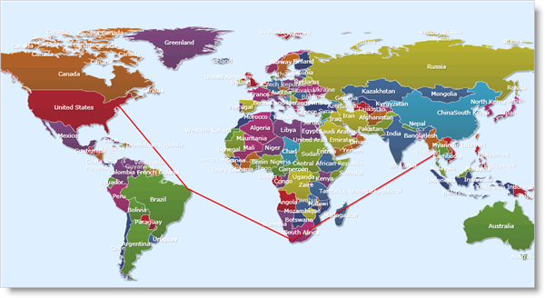
The PathElement object allows you to add lines to your map. This is useful when you want to depict routes and paths on your map. To create a PathElement object, you need to specify points for a line. The origins of these points can be set in Geodetic or Cartesian coordinates. After the points are specified, you can store them as a collection in the MapPolylineCollection object, which is used to set up the line in xamMap™.

The following code shows you how to create a path that goes through four countries using the Imported event of the map layer.

In Visual Basic:

Private Sub worldLayer_Imported(ByVal sender As System.Object, ByVal e As Infragistics.Controls.Maps.MapLayerImportEventArgs)
   If e.Action = MapLayerImportAction.End Then
   ' polyline collection for end-points of line
   Dim lines As New MapPolylineCollection()
   Dim points As New List(Of Point)()
   'US
   points.Add(New Point(-74.535, 40.246))
   'Brazil
   points.Add(New Point(-37, -5))
   'South Africa
   points.Add(New Point(20, -33))
   'Thailand
   points.Add(New Point(100, 15))
   ' Convert Geodetic to Cartesian coordinates
   lines.Add(map1.MapProjection.ProjectToMap(points))
   ' Create path element and set points using polylines
   Dim lineElement As New PathElement()
   lineElement.Polylines = lines
   lineElement.Fill = New SolidColorBrush(Colors.Red)
   lineElement.StrokeThickness = 2
   map1.Layers(0).Elements.Add(lineElement)
   Dim worldRect As Rect = lineElement.WorldRect
   worldRect = lines.GetWorldRect()
   lineElement.WorldRect = worldRect
   End If
   End Sub

In C#:

private void worldLayer_Imported(object sender, Infragistics.Controls.Maps.MapLayerImportEventArgs e)
{
   if (e.Action == MapLayerImportAction.End)
   {
      // polyline collection for end-points of line
      MapPolylineCollection lines = new MapPolylineCollection();
      List<Point> points = new List<Point>();
      // US
      points.Add(new Point(-74.535, 40.246));
      // Brazil
      points.Add(new Point(-37, -5));
      // South Africa
      points.Add(new Point(20, -33));
      // Thailand
      points.Add(new Point(100, 15));
      // Convert Geodetic to Cartesian coordinates
      lines.Add(map1.MapProjection.ProjectToMap(points));
      // Create path element and set points using polylines
      PathElement lineElement = new PathElement() { Polylines = lines };
      lineElement.Fill = new SolidColorBrush(Colors.Red);
      lineElement.StrokeThickness = 2;
      map1.Layers[0].Elements.Add(lineElement);
      Rect worldRect = lineElement.WorldRect;
      worldRect = lines.GetWorldRect();
      lineElement.WorldRect = worldRect;
   }
}
SL DV XamMap Add Path Element 01.png