
This topic provides information on how to display geographic imagery from Bing Maps in the background content of the XamGeographicMap™ control.
The following table lists the topics required as a prerequisite to understanding this topic.
This topic contains the following sections:
The Bing Maps is a licensed geographic imagery mapping service created by the Microsoft® company. This geographic imagery service can be access directly on http://www.bing.com/maps web site. The control displays geographic imagery from the Bing Maps in the map background content using the BingMapsMapImagery class. However, the control by the default displays geographic imagery from the Open Street Maps in the map background content. Therefore, you must configure the control to display geographic imagery from the Bing Maps.
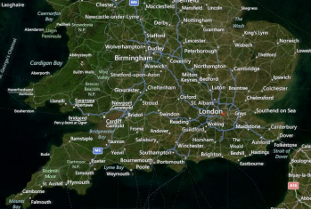
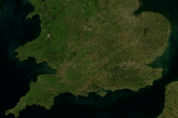
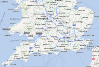
The following images are previews of the control in supported map styles of geographic imagery from the Bing Maps service.
To complete the following procedure, you need to fulfill the following requirements:
The following code provides implementation of the Bing Maps Connector class.
In Visual Basic:
Imports System.Collections.Generic
Imports System.Collections.ObjectModel
Imports System.ComponentModel
Imports System.Net ' HttpWebRequest
Imports System.Runtime.Serialization ' DataContract, DataMember
Imports System.Runtime.Serialization.Json ' DataContractJsonSerializer
Imports System.Windows
Namespace Infragistics.Samples.Services
      ''' <summary>
      ''' <para> Represents a connector class that sets up BingMaps REST imagery service </para>
      ''' <para> and provides imagery tiles via Http web requests.</para>
      ''' <remarks>Bing Maps REST Services: http://msdn.microsoft.com/en-us/library/ff701713.aspx </remarks>
      ''' </summary>
      Public Class BingMapsConnector
            Inherits DependencyObject
            Implements INotifyPropertyChanged
            Public Sub New()
                  Me.IsInitialized = False
            End Sub
            #Region "Events"
            Public Event ImageryInitialized As EventHandler
            Public Event PropertyChanged As PropertyChangedEventHandler
            #End Region
            #Region "Properties"
            ''' <summary>
            ''' Gets or sets an API key required by the Bing Maps imagery service.
            ''' <remarks>This key must be obtained from the http://www.bingmapsportal.com website. </remarks>
            ''' </summary>
            Public Property ApiKey() As String
                  Get
                        Return DirectCast(GetValue(ApiKeyProperty), String)
                  End Get
                  Set
                        SetValue(ApiKeyProperty, value)
                  End Set
            End Property
            Public Const ApiKeyPropertyName As String = "ApiKey"
            Public Shared ReadOnly ApiKeyProperty As DependencyProperty = DependencyProperty.Register(ApiKeyPropertyName, GetType(String), GetType(BingMapsConnector), New PropertyMetadata(String.Empty, Function(o, e) TryCast(o, BingMapsConnector).OnApiKeyChanged(DirectCast(e.OldValue, String), DirectCast(e.NewValue, String))))
            Private Sub OnApiKeyChanged(oldValue As String, newValue As String)
                  Me.Validate()
            End Sub
            Public Const ImageryStylePropertyName As String = "ImageryStyle"
            ''' <summary>
            ''' <para> Gets or sets a map style of the Bing Maps imagery tiles. </para>
            ''' <para> For example: Aerial, AerialWithLabels, or Road map style. </para>
            ''' </summary>
            Public Property ImageryStyle() As BingMapsImageryStyle
                  Get
                        Return CType(GetValue(ImageryStyleProperty), BingMapsImageryStyle)
                  End Get
                  Set
                        SetValue(ImageryStyleProperty, value)
                  End Set
            End Property
            Public Shared ReadOnly ImageryStyleProperty As DependencyProperty = DependencyProperty.Register(ImageryStylePropertyName, GetType(BingMapsImageryStyle), GetType(BingMapsConnector), New PropertyMetadata(BingMapsImageryStyle.AerialWithLabels, Function(o, e) TryCast(o, BingMapsConnector).OnImageryStylePropertyChanged(CType(e.OldValue, BingMapsImageryStyle), CType(e.NewValue, BingMapsImageryStyle))))
            Private Sub OnImageryStylePropertyChanged(oldValue As BingMapsImageryStyle, newValue As BingMapsImageryStyle)
                  Me.Validate()
            End Sub
            Private _tilePath As String
            ''' <summary>
            ''' Gets an imagery tile path for the Bing Maps service.
            ''' </summary>
            Public Property TilePath() As String
                  Get
                        Return _tilePath
                  End Get
                  Private Set
                        _tilePath = value
                        RaiseEvent PropertyChanged(Me, New PropertyChangedEventArgs("TilePath"))
                  End Set
            End Property
            Private _subDomains As ObservableCollection(Of String)
            ''' <summary>
            ''' Gets a collection of image URI sub-domains for the Bing Maps service.
            ''' </summary>
            Public Property SubDomains() As ObservableCollection(Of String)
                  Get
                        Return _subDomains
                  End Get
                  Private Set
                        _subDomains = value
                        RaiseEvent PropertyChanged(Me, New PropertyChangedEventArgs("SubDomains"))
                  End Set
            End Property
            ''' <summary>
            ''' Gets a status whether the Bing Maps service is initialized.
            ''' </summary>
            Public Property IsInitialized() As Boolean
                  Get
                        Return _IsInitialized
                  End Get
                  Private Set
                        _IsInitialized = Value
                  End Set
            End Property
            Private _IsInitialized As Boolean
            ''' <summary>
            ''' Gets or sets whether the Bing Maps service should be auto-initialized upon valid property values.
            ''' </summary>
            Public Property IsAutoInitialized() As Boolean
                  Get
                        Return CBool(GetValue(IsAutoInitializedProperty))
                  End Get
                  Set
                        SetValue(IsAutoInitializedProperty, value)
                  End Set
            End Property
            Public Const IsAutoInitializedPropertyName As String = "IsAutoInitialized"
            Public Shared ReadOnly IsAutoInitializedProperty As DependencyProperty = DependencyProperty.Register(IsAutoInitializedPropertyName, GetType(Boolean), GetType(BingMapsConnector), New PropertyMetadata(False, Function(o, e) TryCast(o, BingMapsConnector).OnAutoInitializedChanged(CBool(e.OldValue), CBool(e.NewValue))))
            Private Sub OnAutoInitializedChanged(oldValue As Boolean, newValue As Boolean)
                  Me.Validate()
            End Sub
            #End Region
            #Region "Methods"
            Private Sub Validate()
                  Me.IsInitialized = False
                  If Not IsValidApiKey() Then
                        Return
                  End If
                  If Me.IsAutoInitialized Then
                        Initialize()
                  End If
            End Sub
            Private Function IsValidApiKey() As Boolean
                  If [String].IsNullOrEmpty(Me.ApiKey) OrElse Me.ApiKey.Length < 20 Then
                        Return False
                  End If
                  Return True
            End Function
            Public Sub Initialize()
                  If Not IsValidApiKey() Then
                        Me.IsInitialized = False
                        System.Diagnostics.Debug.WriteLine("Detected Invalid BingMaps API key: " & Me.ApiKey)
                        Return
                  End If
                  Me.IsInitialized = True
                  ' for more info on setting up web requests to BingMaps REST imagery service
                  ' refer to: http://msdn.microsoft.com/en-us/library/ff701716.aspx
                  Dim bingUrl = "http://dev.virtualearth.net/REST/v1/Imagery/Metadata/"
                  Dim imagerySet = Me.ImageryStyle
                  bingUrl += imagerySet
                  Dim parms = "key=" & Me.ApiKey & "&include=ImageryProviders"
                  Dim url = bingUrl & "?" & parms
                  Dim req = HttpWebRequest.Create(url)
                  req.BeginGetResponse(AddressOf GetResponseCompleted, req)
            End Sub
            #End Region
            #Region "Event Handlers"
            Private Sub GetResponseCompleted(res As IAsyncResult)
                  Dim req = DirectCast(res.AsyncState, HttpWebRequest)
                  Dim response = req.EndGetResponse(res)
                  ' alternatively, parsing of BingResponse can be performed using LINQ to XML
                  ' instead of using JSON deserializer
                  Dim json = New DataContractJsonSerializer(GetType(BingResponse))
                  Dim resp = DirectCast(json.ReadObject(response.GetResponseStream()), BingResponse)
                  If resp.ResourceSets Is Nothing OrElse resp.ResourceSets.Count < 1 OrElse resp.ResourceSets(0).Resources Is Nothing OrElse resp.ResourceSets(0).Resources.Count < 1 Then
                        Return
                  End If
                  Dim imageUrl = resp.ResourceSets(0).Resources(0).ImageUrl
                  Dim subDomains__1 = resp.ResourceSets(0).Resources(0).ImageUrlSubdomains
                  If imageUrl Is Nothing OrElse subDomains__1 Is Nothing Then
                        Return
                  End If
                  TilePath = imageUrl
                  SubDomains = New ObservableCollection(Of String)(subDomains__1)
                  RaiseEvent ImageryInitialized(Me, New EventArgs())
            End Sub
            #End Region
      End Class
      ''' <summary>
      ''' Determines map style for the Bing Maps imagery.
      ''' </summary>
      Public Enum BingMapsImageryStyle
            ''' <summary>
            ''' Specifies the Aerial map style without road or labels overlay.
            ''' </summary>
            Aerial
            ''' <summary>
            ''' Specifies the Aerial map style with road and labels overlay.
            ''' </summary>
            AerialWithLabels
            ''' <summary>
            ''' Specifies the Roads map style without aerial overlay.
            ''' </summary>
            Road
            #Region "Not supported Bing Maps styles by the XamGeographicMap control"
            '''// <summary>
            '''// Specifies the Bird’s eye (oblique-angle) map style
            '''// </summary>
            'Birdseye,
            '''// <summary>
            '''// Specifies the Bird’s eye map style with road and labels overlay.
            '''// </summary>
            'BirdseyeWithLabels,
            #End Region
      End Enum
      <DataContract> _
      Public Class BingResponse
            Public Sub New()
                  ResourceSets = New List(Of BingResourceSet)()
            End Sub
            <DataMember(Name := "resourceSets")> _
            Public Property ResourceSets() As List(Of BingResourceSet)
                  Get
                        Return _ResourceSets
                  End Get
                  Set
                        _ResourceSets = Value
                  End Set
            End Property
            Private _ResourceSets As List(Of BingResourceSet)
      End Class
      <DataContract> _
      Public Class BingResourceSet
            Public Sub New()
                  Resources = New List(Of ImageryMetadata)()
            End Sub
            <DataMember(Name := "resources")> _
            Public Property Resources() As List(Of ImageryMetadata)
                  Get
                        Return _Resources
                  End Get
                  Set
                        _Resources = Value
                  End Set
            End Property
            Private _Resources As List(Of ImageryMetadata)
      End Class
      <DataContract([Namespace] := "http://schemas.microsoft.com/search/local/ws/rest/v1")> _
      Public Class ImageryMetadata
            Public Sub New()
                  ImageUrlSubdomains = New List(Of String)()
            End Sub
            <DataMember(Name := "imageUrl")> _
            Public Property ImageUrl() As String
                  Get
                        Return _ImageUrl
                  End Get
                  Set
                        _ImageUrl = Value
                  End Set
            End Property
            Private _ImageUrl As String
            <DataMember(Name := "imageUrlSubdomains")> _
            Public Property ImageUrlSubdomains() As List(Of String)
                  Get
                        Return _ImageUrlSubdomains
                  End Get
                  Set
                        _ImageUrlSubdomains = Value
                  End Set
            End Property
            Private _ImageUrlSubdomains As List(Of String)
      End Class
End Namespace
In C#:
using System;
using System;
using System.Collections.Generic;
using System.Collections.ObjectModel;
using System.ComponentModel;
using System.Net;                           // HttpWebRequest
using System.Runtime.Serialization;         // DataContract, DataMember
using System.Runtime.Serialization.Json;    // DataContractJsonSerializer
using System.Windows;
namespace Infragistics.Samples.Services
{
    /// <summary>
    /// <para> Represents a connector class that sets up BingMaps REST imagery service </para>
    /// <para> and provides imagery tiles via Http web requests.</para>
    /// <remarks>Bing Maps REST Services: http://msdn.microsoft.com/en-us/library/ff701713.aspx </remarks>
    /// </summary>
    public class BingMapsConnector : DependencyObject, INotifyPropertyChanged
    {
        public BingMapsConnector()
        {
            this.IsInitialized = false;
        }
        #region Events
        public event EventHandler ImageryInitialized;
        public event PropertyChangedEventHandler PropertyChanged;
        #endregion
        #region Properties
        /// <summary>
        /// Gets or sets an API key required by the Bing Maps imagery service.
        /// <remarks>This key must be obtained from the http://www.bingmapsportal.com website. </remarks>
        /// </summary>
        public string ApiKey
        {
            get { return (string)GetValue(ApiKeyProperty); }
            set { SetValue(ApiKeyProperty, value); }
        }
        public const string ApiKeyPropertyName = "ApiKey";
        public static readonly DependencyProperty ApiKeyProperty =
            DependencyProperty.Register(ApiKeyPropertyName, typeof(string), typeof(BingMapsConnector),
            new PropertyMetadata(string.Empty, (o, e) => (o as BingMapsConnector).OnApiKeyChanged((string)e.OldValue, (string)e.NewValue)));
        private void OnApiKeyChanged(string oldValue, string newValue)
        {
            this.Validate();
        }
        public const string ImageryStylePropertyName = "ImageryStyle";
        /// <summary>
        /// <para> Gets or sets a map style of the Bing Maps imagery tiles. </para>
        /// <para> For example: Aerial, AerialWithLabels, or Road map style. </para>
        /// </summary>
        public BingMapsImageryStyle ImageryStyle
        {
            get { return (BingMapsImageryStyle)GetValue(ImageryStyleProperty); }
            set { SetValue(ImageryStyleProperty, value); }
        }
        public static readonly DependencyProperty ImageryStyleProperty =
            DependencyProperty.Register(ImageryStylePropertyName, typeof(BingMapsImageryStyle), typeof(BingMapsConnector),
            new PropertyMetadata(BingMapsImageryStyle.AerialWithLabels, (o, e) =>
                (o as BingMapsConnector).OnImageryStylePropertyChanged((BingMapsImageryStyle)e.OldValue, (BingMapsImageryStyle)e.NewValue)));
        private void OnImageryStylePropertyChanged(BingMapsImageryStyle oldValue, BingMapsImageryStyle newValue)
        {
            this.Validate();
        }
        private string _tilePath;
        /// <summary>
        /// Gets an imagery tile path for the Bing Maps service.
        /// </summary>
        public string TilePath
        {
            get { return _tilePath; }
            private set
            {
                _tilePath = value;
                if (PropertyChanged != null)
                {
                    PropertyChanged(this, new PropertyChangedEventArgs("TilePath"));
                }
            }
        }
        private ObservableCollection<string> _subDomains;
        /// <summary>
        /// Gets a collection of image URI sub-domains for the Bing Maps service.
        /// </summary>
        public ObservableCollection<string> SubDomains
        {
            get
            {
                return _subDomains;
            }
            private set
            {
                _subDomains = value;
                if (PropertyChanged != null)
                {
                    PropertyChanged(this, new PropertyChangedEventArgs("SubDomains"));
                }
            }
        }
        /// <summary>
        /// Gets a status whether the Bing Maps service is initialized.
        /// </summary>
        public bool IsInitialized { get; private set; }
        /// <summary>
        /// Gets or sets whether the Bing Maps service should be auto-initialized upon valid property values.
        /// </summary>
        public bool IsAutoInitialized
        {
            get { return (bool)GetValue(IsAutoInitializedProperty); }
            set { SetValue(IsAutoInitializedProperty, value); }
        }
        public const string IsAutoInitializedPropertyName = "IsAutoInitialized";
        public static readonly DependencyProperty IsAutoInitializedProperty =
            DependencyProperty.Register(IsAutoInitializedPropertyName, typeof(bool), typeof(BingMapsConnector),
            new PropertyMetadata(false, (o, e) => (o as BingMapsConnector).OnAutoInitializedChanged((bool)e.OldValue, (bool)e.NewValue)));
        private void OnAutoInitializedChanged(bool oldValue, bool newValue)
        {
            this.Validate();
        }
        #endregion
        #region Methods
        private void Validate()
        {
            this.IsInitialized = false;
            if (!IsValidApiKey())
            {
                return;
            }
            if (this.IsAutoInitialized)
            {
                Initialize();
            }
        }
        private bool IsValidApiKey()
        {
            if (String.IsNullOrEmpty(this.ApiKey) || this.ApiKey.Length < 20)
            {
                return false;
            }
            return true;
        }
        public void Initialize()
        {
            if (!IsValidApiKey())
            {
                this.IsInitialized = false;
                System.Diagnostics.Debug.WriteLine("Detected Invalid BingMaps API key: " + this.ApiKey);
                return;
            }
            this.IsInitialized = true;
            // for more info on setting up web requests to BingMaps REST imagery service
            // refer to: http://msdn.microsoft.com/en-us/library/ff701716.aspx
            var bingUrl = "http://dev.virtualearth.net/REST/v1/Imagery/Metadata/";
            var imagerySet = this.ImageryStyle;
            bingUrl += imagerySet;
            var parms = "key=" + this.ApiKey + "&include=ImageryProviders";
            var url = bingUrl + "?" + parms;
            var req = HttpWebRequest.Create(url);
            req.BeginGetResponse(GetResponseCompleted, req);
        }
        #endregion
        #region Event Handlers
        private void GetResponseCompleted(IAsyncResult res)
        {
            var req = (HttpWebRequest)res.AsyncState;
            var response = req.EndGetResponse(res);
            // alternatively, parsing of BingResponse can be performed using LINQ to XML
            // instead of using JSON deserializer
            var json = new DataContractJsonSerializer(typeof(BingResponse));
            var resp = (BingResponse)json.ReadObject(response.GetResponseStream());
            if (resp.ResourceSets == null ||
                resp.ResourceSets.Count < 1 ||
                resp.ResourceSets[0].Resources == null ||
                resp.ResourceSets[0].Resources.Count < 1)
            {
                return;
            }
            var imageUrl = resp.ResourceSets[0].Resources[0].ImageUrl;
            var subDomains = resp.ResourceSets[0].Resources[0].ImageUrlSubdomains;
            if (imageUrl == null || subDomains == null)
            {
                return;
            }
            TilePath = imageUrl;
            SubDomains = new ObservableCollection<string>(subDomains);
            if (ImageryInitialized != null)
            {
                ImageryInitialized(this, new EventArgs());
            }
        }
        #endregion
    }
    /// <summary>
    /// Determines map style for the Bing Maps imagery.
    /// </summary>
    public enum BingMapsImageryStyle
    {
        /// <summary>
        /// Specifies the Aerial map style without road or labels overlay.
        /// </summary>
        Aerial,
        /// <summary>
        /// Specifies the Aerial map style with road and labels overlay.
        /// </summary>
        AerialWithLabels,
        /// <summary>
        /// Specifies the Roads map style without aerial overlay.
        /// </summary>
        Road,
        #region Not supported Bing Maps styles by the XamGeographicMap control
        ///// <summary>
        ///// Specifies the Bird’s eye (oblique-angle) map style
        ///// </summary>
        //Birdseye,
        ///// <summary>
        ///// Specifies the Bird’s eye map style with road and labels overlay.
        ///// </summary>
        //BirdseyeWithLabels,
        #endregion
    }
    [DataContract]
    public class BingResponse
    {
        public BingResponse()
        {
            ResourceSets = new List<BingResourceSet>();
        }
        [DataMember(Name = "resourceSets")]
        public List<BingResourceSet> ResourceSets { get; set; }
    }
    [DataContract]
    public class BingResourceSet
    {
        public BingResourceSet()
        {
            Resources = new List<ImageryMetadata>();
        }
        [DataMember(Name = "resources")]
        public List<ImageryMetadata> Resources { get; set; }
    }
    [DataContract(Namespace = "http://schemas.microsoft.com/search/local/ws/rest/v1")]
    public class ImageryMetadata
    {
        public ImageryMetadata()
        {
            ImageUrlSubdomains = new List<string>();
        }
        [DataMember(Name = "imageUrl")]
        public string ImageUrl { get; set; }
        [DataMember(Name = "imageUrlSubdomains")]
        public List<string> ImageUrlSubdomains { get; set; }
    }
}
The following table summarizes important members of the Bing Maps Connector class:
The following procedure demonstrates how to display geographic imagery from Bing Maps in the background content of the XamGeographicMap control.
Add the BingMapsConnector object with your own Bing Maps key and create an event handler for the ImageryInitialized event.
In Visual Basic:
Dim connector As New BingMapsConnector()
connector.ApiKey = "BING_MAPS_API_KEY"
connector.ImageryStyle = BingMapsImageryStyle.Road
connector.ImageryInitialized += OnImageryInitialized
connector.IsAutoInitialized = True
In C#:
BingMapsConnector connector = new BingMapsConnector();
connector.ApiKey = "BING_MAPS_API_KEY";
connector.ImageryStyle = BingMapsImageryStyle.Road;
connector.ImageryInitialized += OnImageryInitialized;
connector.IsAutoInitialized = true;
Implement an event handler for the ImageryInitialized event in order to invoke a method for updating the XamGeographicMap control with geographic imagery from Bing Maps service.
In Visual Basic:
Public Sub OnImageryInitialized(sender As Object, e As EventArgs)
      Dispatcher.BeginInvoke(System.Windows.Threading.DispatcherPriority.Background, DirectCast(Function() UpdateBingMaps(sender), Action))
End Sub
In C#:
public void OnImageryInitialized(object sender, EventArgs e)
{
Dispatcher.BeginInvoke(System.Windows.Threading.DispatcherPriority.Background,
     (Action)(() => UpdateBingMaps(sender)));
}
Implement a method for updating the XamGeographicMap control with geographic imagery from Bing Maps service using the BingMapsMapImagery class.
In Visual Basic:
Private Sub UpdateBingMaps(sender As Object)
      Dim connector = DirectCast(sender, Infragistics.Samples.Services.BingMapsConnector)
      Me.GeoMap.BackgroundContent = New BingMapsMapImagery() With {
            .TilePath = connector.TilePath, .SubDomains = connector.SubDomains }
End Sub
In C#:
private void UpdateBingMaps(object sender)
{
   var connector = (Infragistics.Samples.Services.BingMapsConnector)sender;
   this.GeoMap.BackgroundContent =
      new BingMapsMapImagery()
      {
         TilePath = connector.TilePath,
         SubDomains = connector.SubDomains
      };
}Build and run your project to verify the result. If you have implemented the steps correctly, the displayed should look like the one in the Previews section above.
The following topics provide additional information related to this topic.